We are discussing extreme weather events this week. This video from National Geographic is a great introduction to the material showing the interconnectivity of events.
A coast-to-coast storm is eyeing the U.S. next week, as our extreme weather continues. Things will begin this weekend in the Northwest before the system moves into the Central United States Tuesday. Severe storms are once again likely, with the potential for tornadoes.
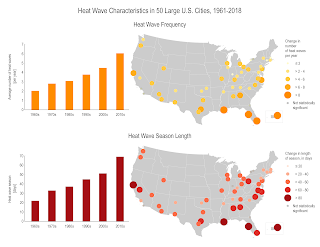
Nevertheless, I'll be focusing on Heat waves this week. They occur more often than they used to in major cities across the United States, from an average of two heat waves per year during the 1960s to more than six per year during the 2010s. ... The average heat wave season across 50 major cities is 47 days longer than it was in the 1960s.
A few summers ago a mega heat wave left California and other Western states enduring the hottest summer on record. That wave killed more than 1 billion sea creatures in the Pacific Northwest!
- Provide community cooling centers, particularly in areas with low-income, elderly, and young populations
- Ensure proper functioning of energy and water systems
- Encourage citizens to check on their family, friends, and neighbors to ensure they have access to air conditioning
- Communicate heat warning information and appropriate responses to the public (e.g., encourage staying indoors, provide symptom reminders)
- Establish systems such as hotlines to alert public health officials about high-risk or distressed individuals
- Encourage energy conservation to reduce demand on electricity systems
- Implement load restrictions for older roads, bridges, and rail to reduce traffic on vulnerable transportation infrastructure
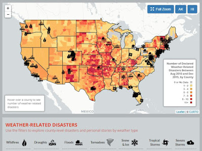
Sites like the Environmental America’s Extreme Weather Map (below) are interactive and help visualize the information of weather-related disasters 2010-2015. Every year, weather-related disasters injure or kill hundreds of Americans and cause billions of dollars in damage. Many of the risks posed by extreme weather will likely increase in a warming world. Scientists have already noted increases in extreme precipitation and heat waves as global warming raises temperatures and exacerbates weather extremes.
The WunderMap is a really useful site to see the severe weather occurrences updated in the States.
Any of the websites I used here are great places to keep yourselves informed so we can prepare for an extreme weather event.
Stay safe and informed!


Oh my GOODNESS!! I was bewildered to find out that 1 billion sea creatures lost their lives to a heat wave a couple years ago. I feel like I do remember a record hot summer a little while back, I had never realized that the animals of the ocean would be as significantly affected by it as they did.
ReplyDelete