9/9/17 UPDATE
Current conditions in the Atlantic in the crisis map map below. Florida told to expect 15ft storm surges as the storm closes in...lrma will regain strength as it moves away from Cuba, with winds predicted of more than 110mph by the time it reaches the Florida Keys early Sunday [more here].
The latest projections from the National Hurricane Center show the storm moving at about 9mph, with winds of 125mph, still over Cuba’s northern shore. The hurricane has not yet turned north back over warmer waters....but it will...
Both coasts told to evacuate due to Irma, now a Cat 5...more info here.
Irma is now a Cat 4 in the Atlantic and it seems Florida has already declared a state of emergency. The predicted path for this hurricane below. Stay tuned....

The only good news I see so far is the INCREDIBLE EFFORT BY CITIZENS TO HELP EACH OTHER. THAT IS SO GREAT TO SEE.
8/28/17 UPDATE.
SO FAR, HARVEY, NOW A TROPICAL STORM MOVING VERY SLOWLY OVER THE SOUTH, IS RESPONSIBLE FOR 99 TORNADO WARNINGS, 6 DEAD PEOPLE, DEVASTATION IN ROCKPORT, CATASTROPHIC FLOODING IN THE HOUSTON AREA [50 INCHES IN SOME AREAS PREDICTED; ENOUGH THAT THE GOVERNOR JUST ACTIVATED 3,000 FEDERAL AND STATE GUARD MEMBERS]. ... AND THIS NOT GOING TO STOP SOON..THE LATEST NEWS PUTS HARVEY BACK ONTO THE GULF AN POSSIBLY STRENGTHENING AGAIN BEFORE HITTING THE SAME AREA IN THE NEXT 120 HOURS..SEE PROJECTED PATH BELOW [CNN]
WE ARE THINKING OF ALL THE AFFECTED, WISHING THEY ARE SAFE AND THAT EVERYONE IS HELPING EACH OTHER.
LOUISIANA NEXT...
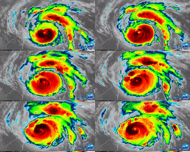
8/25/17. Harvey, currently a Category 3 hurricane, is off the coast of Texas and continues to strengthen…possibly getting close to a Cat 4….you can see the alerts here and the news here. Catastrophic rain to come…predicted up to 35 inches...they are going to get in 2 days all the rain they’d get in 1 year…Hope everyone that did not evacuate is well prepared…some areas will have no electricity for weeks and is expected that pumps will fail and extreme flooding will occur…the map with the latest rain forecast from NOAA is shown below as well as the latest GOES-16 satellite animation.
Current conditions in the Atlantic in the crisis map map below. Florida told to expect 15ft storm surges as the storm closes in...lrma will regain strength as it moves away from Cuba, with winds predicted of more than 110mph by the time it reaches the Florida Keys early Sunday [more here].
The latest projections from the National Hurricane Center show the storm moving at about 9mph, with winds of 125mph, still over Cuba’s northern shore. The hurricane has not yet turned north back over warmer waters....but it will...
Both coasts told to evacuate due to Irma, now a Cat 5...more info here.
Irma is now a Cat 4 in the Atlantic and it seems Florida has already declared a state of emergency. The predicted path for this hurricane below. Stay tuned....
Satellite images show today Harvey's impact on Texas towns. Toggle these images.
After the second landfall, flooding and rescues continue, and the news point to these updates below - Flooding: The heavy rain is over, but parts of Texas remain under inches of floodwater (one Texas town saw a record 51.88 inches of rain during the storm).
- Casualties: At least 37 deaths related to Hurricane Harvey and its aftermath have been reported in Texas.
- Chemical plant fire: Plumes of black smoke were reported after a fire at a flooded chemical plant in Crosby, Texas. The smoke is an irritant, officials say, and residents around the plant have been evacuated.
- Beaumont: The entire city of Beaumont, Texas — population: 118,000 — has no running water after both of its water pumps failed
- Also, lurking in the water, there is potential for
- •Contaminants; Infectious diseases (which will get worse as the sun shines on the water); Insects (for example, fire ants can stick together in the water and form floating colonies); Wildlife, such as alligators and snakes [see below]]

The only good news I see so far is the INCREDIBLE EFFORT BY CITIZENS TO HELP EACH OTHER. THAT IS SO GREAT TO SEE.
8/28/17 UPDATE.
SO FAR, HARVEY, NOW A TROPICAL STORM MOVING VERY SLOWLY OVER THE SOUTH, IS RESPONSIBLE FOR 99 TORNADO WARNINGS, 6 DEAD PEOPLE, DEVASTATION IN ROCKPORT, CATASTROPHIC FLOODING IN THE HOUSTON AREA [50 INCHES IN SOME AREAS PREDICTED; ENOUGH THAT THE GOVERNOR JUST ACTIVATED 3,000 FEDERAL AND STATE GUARD MEMBERS]. ... AND THIS NOT GOING TO STOP SOON..THE LATEST NEWS PUTS HARVEY BACK ONTO THE GULF AN POSSIBLY STRENGTHENING AGAIN BEFORE HITTING THE SAME AREA IN THE NEXT 120 HOURS..SEE PROJECTED PATH BELOW [CNN]
WE ARE THINKING OF ALL THE AFFECTED, WISHING THEY ARE SAFE AND THAT EVERYONE IS HELPING EACH OTHER.
LOUISIANA NEXT...
8/25/17. Harvey, currently a Category 3 hurricane, is off the coast of Texas and continues to strengthen…possibly getting close to a Cat 4….you can see the alerts here and the news here. Catastrophic rain to come…predicted up to 35 inches...they are going to get in 2 days all the rain they’d get in 1 year…Hope everyone that did not evacuate is well prepared…some areas will have no electricity for weeks and is expected that pumps will fail and extreme flooding will occur…the map with the latest rain forecast from NOAA is shown below as well as the latest GOES-16 satellite animation.
STAY TUNED...


