Saturday, October 19, 2019

Week 10-Extreme Weather in the US


As we currently watch post tropical cyclone Nestor approach Florida [see image below from NHC], a round of severe thunderstorms, with damaging winds, hail and isolated tornadoes, is possible Sunday and Monday from the Plains to the lower Mississippi Valley. The chance of severe weather will build due to a familiar early winter-like setup that includes the intersection of a strong low-pressure system with warmer, more humid air ahead of it from the Gulf of Mexico.


The Weather Prediction Center shows the map below for tomorrow, with further predictions of thunderstorms moving east with each passing day.

As expected, 2018 was the fourth-hottest year on record globally, and another near-record year for U.S. weather and climate disasters, see image below. 


While the U.S. had its 14th-warmest year in 2018, unusual heat in Europe and the Arctic propelled the globe to higher numbers. The oceans also had their warmest year on record — a trend that intensifies sea level risecoral bleaching, and tropical cyclones such as hurricanes.

Any of these websites are great places to keep yourselves informed so we can prepare for a heat wave or a storm coming our way.

Saturday, October 5, 2019

Week 8-Mass Wasting Events in the US


Landslides in the United States cause approximately $3.5 billion in damage, and kill between 25-50 people annually. The largest landslide in modern U.S. history (in terms of volume) was most likely one that occurred in 2013 in Bingham Canyon outside of Salt Lake City, Utah. It had a slide mass of 55 million cubic meters (compared to an estimated 10 million cubic meters during the Oso event in 2014, see image below).
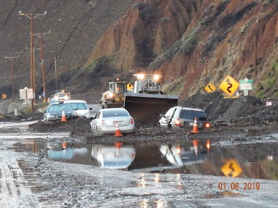
Landslides impact California’s terrain often. These are generally related to precipitation patterns, in particular if there has been previous months of drought conditions. In January 2019, Pacific storms brought a lot of rainfall to the state. The heavy rain forced residents to evacuate from wildfire-ravaged areas. The “high risk” areas for mudslides are so because they are adjacent to steep slopes or are located at the base of drainage areas. Recent examples are the ‘Woolsey’ and the ‘Hill’ fire burn areas, which will be subject to high volume of mud and debris flow moving forward. The photo below shows a 2019 example.


Oso mudslide image

If you want to know more about these hazards, the USGS page has great information on how to identify landslides and what to do if one happens. If you want to know if you are living in a risk area, you can access maps like the USGS below that shows the Emergency Assessment of Post-Fire Debris-Flow Hazards.

image of the 2019 aftermath of landslides in south CA

Stay informed and safe-