We are discussing extreme weather events this week. This video from National Geographic is a great introduction to the material showing the interconnectivity of events.
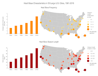
I'll be focusing on Heat waves. They occur more often than they used to in major cities across the United States, from an average of two heat waves per year during the 1960s to more than six per year during the 2010s. ... The average heat wave season across 50 major cities is 47 days longer than it was in the 1960s.
This summer the mega heat wave left California and other Western states enduring the hottest summer on record. That wave killed more than 1 billion sea creatures in the Pacific Northwest!
- Provide community cooling centers, particularly in areas with low-income, elderly, and young populations
- Ensure proper functioning of energy and water systems
- Encourage citizens to check on their family, friends, and neighbors to ensure they have access to air conditioning
- Communicate heat warning information and appropriate responses to the public (e.g., encourage staying indoors, provide symptom reminders)
- Establish systems such as hotlines to alert public health officials about high-risk or distressed individuals
- Encourage energy conservation to reduce demand on electricity systems
- Implement load restrictions for older roads, bridges, and rail to reduce traffic on vulnerable transportation infrastructure
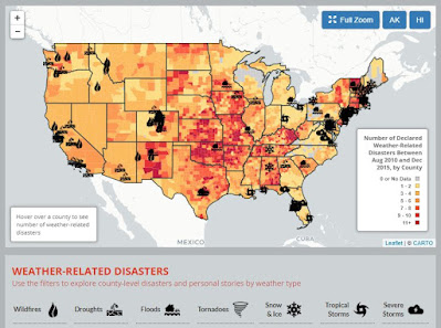
Sites like the Environmental America’s Extreme Weather Map (below) are interactive and help visualize the information of weather-related disasters 2010-2015. Every year, weather-related disasters injure or kill hundreds of Americans and cause billions of dollars in damage. Many of the risks posed by extreme weather will likely increase in a warming world. Scientists have already noted increases in extreme precipitation and heat waves as global warming raises temperatures and exacerbates weather extremes.
The WunderMap is a really useful site to see the severe weather occurrences updated in the States.
Any of the websites I used here are great places to keep yourselves informed so we can prepare for an extreme weather event.
Stay safe and informed!


Hello Ms. Garcia
ReplyDeleteYour visual aids that you used throughout your post gave me a better understanding of your topic. Its amazing to see how different weather conditions occur throughout the same country.
Absolutely; these maps are visually very helpful!
ReplyDeleteHello Ms. Garcia
ReplyDeleteI like how you talked about the sea animals dying during the California heat wave so sad I had no idea! Hope my little friends who visited me while surfing survived this summer :c. Gives me much more appreciation for sea life.
Good Evening Ms. Garcia,
ReplyDeleteI love your visuals always so thank you for that! I do find it interesting how how it gets here in California and since I live in Salinas I do love the weather but it changes dramatically. I do feel though with the time the world is going to get hotter and who knows what may happen to the next generations mother earth is going through a lot especially with all the toxins and pollution that is put out in the air and all over the world.
Hello Ms.Garcia!
ReplyDeleteThe images you showed us was very helpful and understanding. I enjoyed reading your blog!
Hi Ms.Garcia,
ReplyDeleteGreat job with this weeks blog.I really liked how you were able to explain your response very thorough.I was able to have a much better understanding with California's heat waves.