UPDATE 4/5/17-The National Weather Service issued tornado and flash-flood warnings for counties across Georgia on Wednesday afternoon as a system of storms barreled through the Southeastern United States. The storms were expected to leave nearly 60 million people at risk of tornadoes, damaging winds, thunderstorms and flooding, according to a CNN forecast.
This week we are exploring extreme weather events.
This week we are exploring extreme weather events.
In the
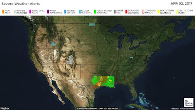
figure from the weather channel below you
can see how today in the south there are a few flash flood and t-storms watches.
Knowing your weather patterns
matters.
As we have learned in class, a watch and a warning is a very different type of hazard. Knowing what to do in each one is very useful once the extreme weather condition affects you. There are so many types of extreme weather hazards that the mitigation efforts will be very different for each one. Being well informed is your best weapon. Both sites I posted here have twitter feeds you can follow.
Be informed. Be ready.


Hi professor!
ReplyDeleteI had no idea that the south was experiencing this kind of weather this time of year! Your images were great- I enjoyed looking at the convective map; I'm interested in how they come up with the classifications such as "marginal" or "slight". The classification names seem a bit biased (?). I also think it is cool that that they are using Twitter to get information out to the public- not only is it easy to follow, but I think it can reach a larger audience. I think more areas should start using this tool!
hi- i think these models run with a lot of real in situ data and some probability formula that makes them think an area has more or less risk. Of course some models will be more accurate than others..
DeleteKnowing when a serious weather hazard is coming is very important. It can save lives and property as well. Canada faces many types of extreme weather and they have good warning systems put in place. Environment Canada uses the internet. This allows people to check and stay updated for warnings and weather watches as well. They have a interactive map as well as other helpful weather information. For example today in Dempster, Canada there is a blizzard warning. This can be found at the following website: https://weather.gc.ca/warnings/report_e.html?yt2. Canada also uses twitter for immediate information about serious weather hazards and conditions as well. This is an updated system put in place to help people prepare and make safely arrangements.
ReplyDeleteHello professor, very informative post! Wow, I was unaware that the southeast is at such high risk for tornadoes and flash foods. It's good to know the National Weather Service had issued warnings to let residents take appropriate measures to prepare..great visuals too..clearly can see the areas that are on watch for flash floods and storms..
ReplyDeleteThe core message of being informed and ready really is what I find to be the major take away from this post. There are great resources out there and having dedicated stations like the weather channel is something I find many people take for granted.
ReplyDeleteHello Professor Garcia, I have also been staying updated on the weather these parts of the country are dealing with. I can't imagine the feeling people get knowing a tornado could head their way at anytime, something we have yet to experience in California. The second image provides a clear example of where these storms are located. Because the weather is constantly changing, I think California will face more serious weather in the future. Weather that is similar to the the recent rain storms which caused serious flooding. Thanks for your post!
ReplyDelete