Saturday, August 31, 2024

Week 3: Earthquakes

 We are exploring earthquakes and what countries do to prevent/mitigate the hazard. If I want to know something about earthquakes in a place, the first websites I go to are: the USGS Real Time Earthquakes Website or the IRIS monitoring website.


Regarding where quakes are located in the US, the new seismicity map below from USGS shows the (obvious, in red) ring of fire portion on the West coast but also a central area in the middle of the plate. I’d like to talk a bit more about this non-obvious one. This area, called the New Madrid Zone was shaken by a M8(!) in 1811. The reason for the activity is a very old intraplate rift placed below the area (see image from http://showme.net).

USGS 2023 Seismic Hazard Map


The San Andreas Fault System is responsible for most of California natural quakes...Each year the southern California area has about 10,000 earthquakes.!! The latest swarm of quakes in the Salton Sea has been featured in the news often. Earthquakes up to magnitude 4.6 under the Salton Sea are raising concern that a larger quake could be unleashed on the San Andreas fault. The southernmost section of the fault has not ruptured since about 1680.

So, what can we do about it?; apart from the obvious need for education, I want to focus on the USGS ShakeAlert system, developed for the West coast using some of the existing systems. Today, the technology exists to detect earthquakes, so quickly, that an alert can reach some areas before strong shaking arrives. The purpose of an EEW (Earthquake Early Warning) system is to identify and characterize an earthquake a few seconds after it begins, calculate the likely intensity of ground shaking that will result, and deliver warnings to people and infrastructure in harm’s way. Studies of earthquake early warning methods in California have shown that the warning time would range from a few seconds to a few tens of seconds, depending on the distance to the epicenter of the earthquake. 
There is an Earthquake Tracker all Californians can download to keep informed: try My Shake App.


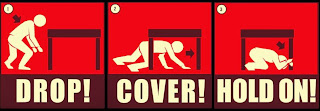
A few seconds of warning could make all the difference (enough to stop transit/elevators and to drop, cover, hold on).This year's International ShakeOut Day is October 17, when millions of people worldwide will participate in earthquake drills at work, school, or home!


Being aware of the risk and know what to do when the shaking starts is very important. We know that earthquakes cannot be predicted (I recommend Dr. Jones’ book called the big ones if you want more information about that)

Saturday, August 24, 2024

Week 2: Tectonic Plates and Boundaries

 This week we are exploring Plate Tectonics and how important it is to know the location of the plate boundaries, and how it is closely related to some natural hazards, like volcanoes or earthquakes.


In the US, the NOAA map below shows how the Easter part of the States is a passive margin, and the Western side of the country is a very active one, with the Pacific Plate, Cocos, Juan de Fuca plates connecting to the North American plate. Not a surprise we are on the ‘Ring of Fire’, where a lot of the volcanic and seismic activity happens!

Closer to home, the transform plate boundary called SAF (San Andreas Fault) is responsible for most of the shakingThese plates (North American and Pacific) are slowly moving past one another at a couple of inches a year; about the same rate that your fingernails growOur amazing SAF is also a right strike slip fault. 


Of course, there are a few exceptions, like the activity of Hawaii within the Pacific plate (hot spot) or the New Madrid area (ancient rift) within the North American Plate, both not at plate boundaries, but that will be another post another time...

We might not know when events like volcanic eruptions or big earthquakes will happen (a lot of these happen underwater...), but if you know your Tectonics, you definitely know WHERE they (mostly) do!

Sunday, August 18, 2024

Week 1 (Geol9): introducing the US

  Hello Geol9,


Welcome to class. 


During the semester, we will all explore the natural hazards of numerous countries around the world, why they happen, and what mitigation and adaptation measures we have in place to help manage them.

As my students learn about all this, I'll be blogging alongside them using the US as an example.

The Unites States of America is primary located in North America and the third largest country of the world by land and total area. The U.S. consists of 50 states, a federal district, five major unincorporated territories, nine Minor Outlying Islands and includes 326 Indian reservations (see its map below). Its population in 2022 was 333.3 million!

Students this week will learn the differences between a natural hazard, a catastrophe, and a disaster.

It will be fun exploring all its natural hazards with you!- Stay tuned...