When I think about coastal erosion, I think about Pacifica, CA, and the 2016 after el Niño related storms, when yet another chunk of sandy cliff was falling into the ocean and houses were in need of abandonment. A drone video of the area is clear. A lot of information can be found about how in a few years the cliff has eroded.
Saturday, November 7, 2020
Coastal Hazards in the US
Sunday, October 18, 2020
Extreme Weather in the States
We are discussing extreme weather events this
week. This
video from National Geographic is a great
one as an introduction to the material.
As I write this, California just had the
hottest August and September on record. The high temperature 97°
in #SantaCruz
on Friday, October 16th exceeded the previous record 96° on this day in 1974
and 1967.
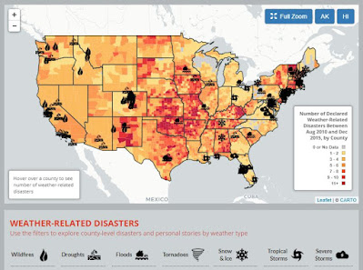
On sites like the Environmental America’s Extreme Weather Map (below) one can see an interactive visual map with information of weather-related disasters 2010-2015. Every year, weather-related disasters injure or kill hundreds of Americans and cause billions of dollars in damage. Many of the risks posed by extreme weather will likely increase in a warming world. Scientists have already noted increases in extreme precipitation and heat waves as global warming raises temperatures and exacerbates weather extremes.
The WunderMap is a really useful site to see the severe weather occurrences updated in the States.
Any of the websites I used here are great places to keep yourselves informed so we can prepare for an extreme weather event.
Stay safe and informed!
Saturday, October 3, 2020
Mass Wasting in the USA
This week we are discussing 'mass wasting' events...
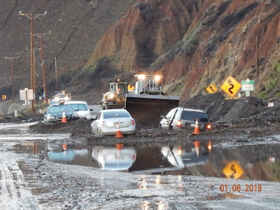
Landslides in the United States cause approximately $3.5 billion in damage, and kill between 25-50 people annually. The largest landslide in modern U.S. history (in terms of volume) was most likely one that occurred in 2013 in Bingham Canyon outside of Salt Lake City, Utah. It had a slide mass of 55 million cubic meters (compared to an estimated 10 million cubic meters during the Oso event in 2014, see image below).
If you want to know more about these hazards, the USGS page has great information on how to identify landslides and what to do if one happens. If you want to know if you are living in a risk area, you can access maps like the USGS below that shows the Emergency Assessment of Post-Fire Debris-Flow Hazards.
Stay informed and safe-
Saturday, September 12, 2020
Volcanoes in the USA
Saturday, August 29, 2020
Week 3: Earthquakes
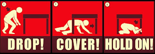
This week we are exploring earthquakes and what countries do to prevent/mitigate the hazard. If I want to know something about earthquakes in a place, the first websites I go to are: the USGS Real Time Earthquakes Website or the IRIS monitoring website.
Friday, August 21, 2020
Week 2: Tectonics
This week 2 we are exploring plate tectonics and how important it is to know the location of the plate boundaries, and how it is closely related to some natural hazards, like volcanoes or earthquakes.
Saturday, August 8, 2020
Welcome to Fall 2020, Geol9!
Hello Geol9,
Welcome to class.
If the first two months of the season was a sign of things to come, it's going to be a long hurricane season. With the climatological peak still over a month away, the chances of an above-average number of storms is increasingly likely.
In fact, forecasters at NOAA recently updated their predictions for the season. They are now suggesting that 2020 will be one of the busiest hurricane seasons on record!
In this first post of the semester, Geol9 students will discuss the differences between catastrophes, diasasters, and natural hazards. They'll also post briefly about someone (a scientist) who they identify with.
My chosen geologist is Marie Tharp, who made great contributions to seafloor mapping and is a great inspiration to women in science! (Soundings is a good book about her life)
Stay tuned for those natural hazards...
Sunday, April 26, 2020
Coastal Hazards in the States
 Probabilities of Shoreline Change: ‘this dataset was used to develop and evaluate the performance of a Bayesian network (BN) that predicts long-term shoreline change associated with sea-level rise. The BN is used to define relationships between driving forces, geologic constraints, and coastal response, which includes observations of local rates of relative sea-level rise, wave height, tide range, geomorphology, coastal slope, and rate of shoreline change. Using this information, the BN is used to make probabilistic predictions of shoreline change in response to different future sea-level rise scenarios’.
 Friday, April 3, 2020
Week 10: Extreme weather in the US
 As I write this, developing weather pattern is predicted to unleash severe weather across Texas, at the same time as potential repeated downpours and flooding problems into the second week of April. Much of the central and southern parts of the state have been experiencing abnormally dry to severe drought conditions in recent months due to a significant deficit in rainfall. AccuWeather Lead Storm Warning Meteorologist Brian Knopick said that scattered strong to severe thunderstorms will erupt in south-central Texas during the afternoon then drift southward into the evening hours. Large hail, localized damaging winds and flash flooding are expected to be the main threats from the storms.
Stay safe and informed!
Sunday, March 15, 2020
Week 8: Mass Wasting in the States
This week I wanted to send my support to all affected by COVID-19 and encourage everyone to stay calm and informed and to practice social distancing as a real way to help the spread and overall consequences of this current virus.
This week we are discussing 'mass wasting' events in Geol9...
Landslides in the United States cause approximately $3.5 billion in damage, and kill between 25-50 people annually. The largest landslide in modern U.S. history (in terms of volume) was most likely one that occurred in 2013 in Bingham Canyon outside of Salt Lake City, Utah. It had a slide mass of 55 million cubic meters (compared to an estimated 10 million cubic meters during the Oso event in 2014, see image below).
If you want to know more about these hazards, the USGS page has great information on how to identify landslides and what to do if one happens. If you want to know if you are living in a risk area, you can access maps like the USGS below that shows the Emergency Assessment of Post-Fire Debris-Flow Hazards.
Stay informed and safe-
Saturday, February 22, 2020
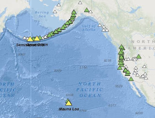
Volcanic Hazards in the USA
USGS volcanic hazards 2/22/20
|


